Log in to your NBOS account to upload files
| Recent Uploads | |
|---|---|
| Jörðgarð Map No. 517 - Alderli | 02/28/2025 |
| Jörðgarð Map No. 516 - Elven Cottage in the Wood | 02/07/2025 |
| Jörðgarð Map No. 515 - Settlement Ruin | 01/20/2025 |
| Jörðgarð Map No. 514 Fork in the Trail | 01/17/2025 |
| Jörðgarð Map No. 513a - Riddle Bridge | 01/17/2025 |
| Most Downloaded | |
|---|---|
| NBOS Character Sheet Designer v2.0 | 129397 |
| Inspiration Pad Pro 3.0 | 24001 |
| Inspiration Pad Pro 2.0 | 18282 |
| Fractal Mapper 8 PDF | 13200 |
| ScreenMonkey Lite 1.8k | 9769 |
Jörðgarð Map of the Week #435 - North Kingdom Camps
Contributor:
MarkOliva
Rating:
Date Added:
01/19/2020
Downloads:
1134
Description:
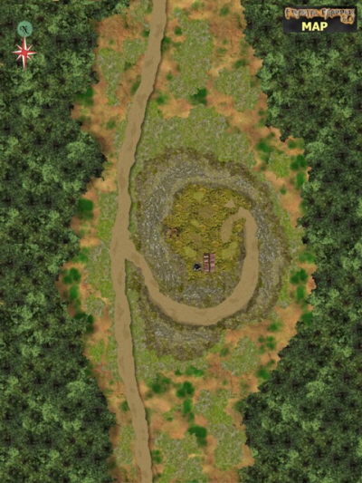
Map of the Week No. 435 is from the forthcoming Jörðgarð Trails adventure "A Tale of 2 Books." The map shows the layout of the standard campsites in the isolated and unsettled areas of the vampire-ruled North Kingdom between Kingsgate and Vladimir's Throne. These campsites were made to provide defensible camping places for military patrols and trade caravans, and all are almost identical. For the reason, this section applies to all four sites. The road through the campsites is raised. It's about 18 inches/45 cm higher than the surrounding terrain. The Æsir built this road when the area still was a part of the fallen Æsir Empire. The Æsir laid a thick gravel bed on the path of the road so that it could handle heavy timber wagons, regardless of the weather. The clearings where the camps are and the artificial hills also were made by the Æsir. The North Kingdomi restored the abandoned roads. The Æsir also made the somewhat circular hills by bringing large numbers of fieldstones to the clearing and mixing them with soil while mounding them. The mounds are about 40 feet/12 meters above the surrounding terrain, giving defending campers something of an advantage over possible attacks from below. Atop the mounds are primitive wooden watch towers, each 20 feet/6 meters high, a fire ring and a few cords of firewood.
You can get this map in two versions:
1. The Fractal Mapper (TM) 8 version in FMP format (1.9 MB) from the Jörðgarð website.
2. As a JPG flat map of 1360 x 1020 Pixels (490 KB) with the link below.
Both versions are released for personal and commercial use under the Open Game License Version 1.0a, which you can read on the Jörðgarð website at:
www.vintyri.org/joerdhgardh/index.htm
Next Week: Village of Woodcut