Log in to your NBOS account to upload files
| Recent Uploads | |
|---|---|
| Add Custom Field Example Plugin | 04/05/2024 |
| Inspiration Pad Pro v3.0 for Android | 04/03/2024 |
| Jörðgarð Maps No. 505 - Wayhouse 2nd Story | 03/08/2024 |
| Jörðgarð Map No. 504 - Wayhouse Ground Floor | 03/08/2024 |
| Jörðgarð Map No. 503 - Stillwood | 02/06/2024 |
| Most Downloaded | |
|---|---|
| NBOS Character Sheet Designer v2.0 | 123661 |
| Inspiration Pad Pro 3.0 | 22164 |
| Inspiration Pad Pro 2.0 | 17617 |
| Fractal Mapper 8 PDF | 12311 |
| ScreenMonkey Lite 1.8k | 9209 |
Jörðgarð Map of Week #188 - Pumice Mines
Contributor:
MarkOliva
Rating:
Date Added:
01/25/2015
Downloads:
1211
Description:
With the 188th Map of the Week, we take a look at the abandoned pumice mines near the village of Goldfields in the northern Border March of Slovania.
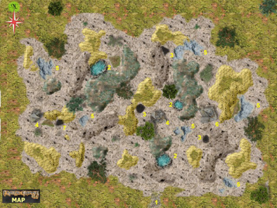
Description of the Map Locations
Location No. 1: At this point, the tall grass and low brush end, ending in a landscape dominated by foamy grey-brown and dirty yellow rock. Both are forms of pumice. It is said that the Austamæra Æsir used pozzolan type pumice to produce an early form of concrete. That invention gave birth to the Æsir town of Vikur (Pumice), which stood on the site of today's Goldfields. The Austamæra pumice mines and the artisans of Vikur produced the concrete blocks of which many structures in the southern Æsir Empire were built. In Goldfields, the two gate towers and the scattered remnants of the old wall are of concrete brick made by the stonemasons of Vikur. Unfortunately, the Slovanians lack the technical knowledge and skill of the Æsir. They do not known how to make concrete or anything else of pumice. As a result, the mines are abandoned and ignored.
Locations Numbered 2: Depressions of some sort in which rain water accumulates.
Locations Numbered 3: Openings to subterranean shafts or tunnels.
Locations Numbered 4: Clusters of large rocks.
Locations Numbered 5: Lime pits.
You can get this map in two versions:
1. The Fractal Mapper (TM) 8 version in FMP format, fully editable (30 MB) from the Jörðgarð website.
2. As a JPG flat map of 1360 Pixels x 1270 Pixels (740 KB), available with the hyperlink below.
Both versions are released for personal and commercial use under the Open Game License Version 1.0a, which you can read on the Jörðgarð website at:
www.vintyri.org/joerdhgardh/
Next Week: The Halfling Hideout
Mark Oliva
The Vintyri (TM) Project
www.vintyri.org
info@vintyri.org