Log in to your NBOS account to upload files
| Recent Uploads | |
|---|---|
| Jörðgarð Map No. 517 - Alderli | 02/28/2025 |
| Jörðgarð Map No. 516 - Elven Cottage in the Wood | 02/07/2025 |
| Jörðgarð Map No. 515 - Settlement Ruin | 01/20/2025 |
| Jörðgarð Map No. 514 Fork in the Trail | 01/17/2025 |
| Jörðgarð Map No. 513a - Riddle Bridge | 01/17/2025 |
| Most Downloaded | |
|---|---|
| NBOS Character Sheet Designer v2.0 | 129437 |
| Inspiration Pad Pro 3.0 | 24007 |
| Inspiration Pad Pro 2.0 | 18285 |
| Fractal Mapper 8 PDF | 13206 |
| ScreenMonkey Lite 1.8k | 9775 |
Jörðgarð Map of Week #180 - Witch Towers
Contributor:
MarkOliva
Rating:
Date Added:
11/17/2014
Downloads:
1334
Description:
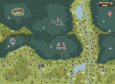
With the 180th Map of the Week, we take a look at Witch Towers, the ruling seat of the northwestern island kingdom Northland, the largest realm of the Dark Elves known in the western jörð. Northland is under the harsh rule of the Witch Queen Luohi, who has robbed most of her dark elven subjects of a part of their intelligence in order to use it to augment her own power.
Key to the Map of Witch Towers:
GAME MASTER'S NOTE: Graphically, the map shows Witch Towers during the warm season. During the cold part of the year, most of this area is under snow. The unnumbered buildings all are dark elf huts.
1. Blackcastle. The dark elven Witch Queen Luohi's castle complex.
2. Black Mountain. 2,000 feet/600 meters high.
3. Magic Castle. Home to the Witch Queen's wizards and sorcerers who deal mainly in conjuration, transmutation, evocation and abjuration.
4. Lightning Mountain. 1,800 feet/540 meters high.
5. Castle of the Eye. Home to the Witch Queen's wizards and sorcerers who deal mainly in divination.
6. Bearmount. 2,300 feet/780 meters.
7. Uncastle. Home to the Witch Queen's wizards and sorcerers who deal mainly in illusion and enchantment.
8. Kettlemount. 1,600 feet/480 meters.
9. Northguard. 1,700 feet/540 meters.
10. Southguard. 1,500 feet/450 meters.
11. Mill Valley. The areas north of the Grainfrost River and the north millstream confluence have stony soil ill-suited for farming.
12. Grainfrost River.
13. North Millpond.
14. Northmill A small sawmill with a bottom driven waterwheel and three woodsheds.
15. North Millstream.
16. Stormroad. Leads to Stormfields, about 250 miles/400 km to the east.
17. Tannery.
18. Meat Packing Plant.
19. Searoad.
20. South Millpond.
21. South Millstream.
22. Southmill. A grain mill with a bottom driven waterwheel and three sheds.
23. Speakers House. This is something of a döark elven village hall.
24. West Trail. This poor road leads to West Bay, some 700 miles/1,120 km to the northwest. It seldom bears traffic.
You can get this map in two versions:
1. The Fractal Mapper (TM) 8 version in FMP format, fully editable (33 MB) from the Jörðgarð website.
2. As a JPG flat map of 1360 Pixels x 1000 Pixels, (630 KB), available with the hyperlink below.
Both versions are released for personal and commercial use under the Open Game License Version 1.0a, which you can read on the Jörðgarð website at:
www.vintyri.org/joerdhgardh/
Next Week: Northland - Southport
Mark Oliva
The Vintyri (TM) Project
www.vintyri.org
info@vintyri.org