Log in to your NBOS account to upload files
| Recent Uploads | |
|---|---|
| Jörðgarð Map No. 517 - Alderli | 02/28/2025 |
| Jörðgarð Map No. 516 - Elven Cottage in the Wood | 02/07/2025 |
| Jörðgarð Map No. 515 - Settlement Ruin | 01/20/2025 |
| Jörðgarð Map No. 514 Fork in the Trail | 01/17/2025 |
| Jörðgarð Map No. 513a - Riddle Bridge | 01/17/2025 |
| Most Downloaded | |
|---|---|
| NBOS Character Sheet Designer v2.0 | 129402 |
| Inspiration Pad Pro 3.0 | 24001 |
| Inspiration Pad Pro 2.0 | 18283 |
| Fractal Mapper 8 PDF | 13203 |
| ScreenMonkey Lite 1.8k | 9772 |
Jörðgarð Map of Week #85 - Dwarven Highway Flooding
Contributor:
MarkOliva
Rating:
Date Added:
11/18/2012
Downloads:
1543
Description:
With the 85th Map of the Week we continue in the borderlands town of Óðinn's House in the Kingdom of Slovania. This week we take a look at the flooded area of the subterranean Dwarven Highwy extension.
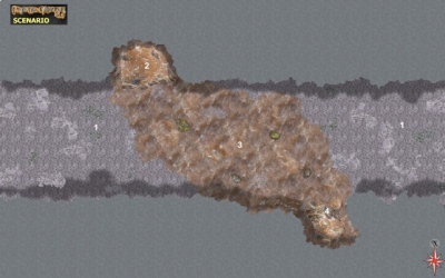
Key to the flooded area (Highway Location No. 5)
This is another area with a riddle that the Northern Circle has yet to unravel. It appears that an underground stream cut a fissure into the north wall of the highway, permitting the stream's water to flow down the sides of the cut and across the highway, where it cut another descending fissure into the south wall, allow the water to drain into the unknown depths. So it appears, but a close examination has convinced the circle's members that someone of something than the underground stream intentionally cut the fissures into the two walls. The druids of the fortress have no idea who or what that might have been, much less why. Only the game master knows the answer to these questions; there is and will be no official answer.
1. Highway extension. The tunnel is roughly 20 feet/6 m wide and 10 feet/3 m high.
2. Inflow fissure.
3. Flood water. The muddy silt water flows from north (top) to south (bottom) across the road.
4. Outflow fissure.
You can get this scenario in two versions:
1. The Fractal Mapper (TM) 8 map in FMP format, fully editable, from our Jörðgarð web page (11.5 MB).
2. As a JPG flat map of 1360 Pixels x 850 Pixels (480 KB), available with the hyperlink below.
Both versions are released for personal and commercial use under the Open Game License Version 1.0a, which you can read on the Jörðgarð website at:
www.vintyri.org/joerdhgardh/joerdhgardh.htm
Next week: Óðinn's Fortress - The Dwarven Highway's Twin Graves
Mark Oliva
The Vintyri (TM) Project
www.vintyri.org
info@vintyri.org