Log in to your NBOS account to upload files
| Recent Uploads | |
|---|---|
| Jörðgarð Map No. 517 - Alderli | 02/28/2025 |
| Jörðgarð Map No. 516 - Elven Cottage in the Wood | 02/07/2025 |
| Jörðgarð Map No. 515 - Settlement Ruin | 01/20/2025 |
| Jörðgarð Map No. 514 Fork in the Trail | 01/17/2025 |
| Jörðgarð Map No. 513a - Riddle Bridge | 01/17/2025 |
| Most Downloaded | |
|---|---|
| NBOS Character Sheet Designer v2.0 | 129436 |
| Inspiration Pad Pro 3.0 | 24007 |
| Inspiration Pad Pro 2.0 | 18285 |
| Fractal Mapper 8 PDF | 13206 |
| ScreenMonkey Lite 1.8k | 9775 |
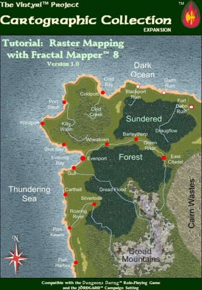
Vintyri FM8 Raster Mapping Tutorial Released
Contributor:
MarkOliva
Rating:
Date Added:
03/10/2010
Downloads:
1888
Description:
We're two and a half months behind our original plan, but our free and open PDF tutorial for raster mapping with FM8 is at last available for download. The product includes a 222-page illustrated and bookmarked PDF (40 MB) and a collection of necessary support files (47 MB). This product is a second level instruction booklet that takes up where the free NBOS manual-tutorial leaves off. The material all is presented in step-for-step detail with more than 270 color screen shots and illustrations intended to keep things understandable and easy. It goes from the surface of raster mapping with FM8 into areas that usually are viewed as being of expert level. However, because FM8 itself is so simple to use, even inexperienced mappers should be able to master everything in this volume with little trouble. It should be noted that anyone pondering whether FM8 is the right tool can work his or her way through this tutorial without buying anything. It will work with the free trial version of FM8 or with the full purchase version. All other software required for the tutorial can be downloaded free and legally in the Internet. The first chapter shows the cartographer how to best set FM8 up for raster mapping while explaining why these settings are made and what their advantages are. It also explains what other free software products might be desirable and where to download all of them at no cost. The second chapter takes the reader step-by-step through the making of the overland map on the cover of the booklet, producing it with two entirely different alternative ocean types. The third chapter offers step-by-step instructions on how to create an FM8 "super zoom" map of a city, town or village. Chapter 4 deals with the raster mapping of floor plans and dungeons in multi-layer technique. This chapter devotes special attention to the mapping of a dungeon or floor plan in such a manner that the game master easily can show his or her players all things that their PCs can see and hide all things that they haven't seen yet. In Chapter 5 one begins to see how to get the power of all of FM8's horses into a map. The RPG world has a thing with raster maps. It's said that if everything in a raster map is scaled fine, it looks like a mish mash on strong zoom-outs. On the other hand, one claims, if things are scaled right for a wide scale raster map, most objects pixilate terribly on close zoom-ins. With a number of graphic programs that's quite true. FM8 is one of relatively few programs used to make RPG maps where this doesn't need to be the case at all. FM8 has zoom controls that can and should make such problems superfluous in your map. When you use FM8 well, important objects in your maps will have different scales at different zoom levels. Chapter 5 shows how that works. There also are many game masters and cartographers who would like to have maps so versatile that one could zoom in on any settlement on the map, and instead of seeing the isometric or cartographic symbol that had been there, one would see a totally zoomable, detailed map of the settlement. Chapter 5 usees a large scale overland map with scale dimensions of 3,900 by 2,800 miles. The region mapped includes the town which was mapped in detail in Chapter 3. When one zooms in on this town in the overland map, one sees the town map, completely zoomable down to the individual wood piles and outhouses. Chapter 6 takes on another important theme for raster mappers: The making of presets is important knowledge for any serious mapper. Presets make it possible for a raster cartographer to fill large areas quickly with credible symbols in full quality and with full zoom abilities. Chapter 7 shows how to use FM8 to make raster symbols. For all of FM8's power, there are some things it can't do. One of them is to create symbols with transparent elements. FM8 can't do that, but it's an easy chore with a free graphic program like Paint.NET. Chapter 8 starts out with a digital photo of two chickens that supposedly are of a race bred already in the 1400s and 1500s - two medieval chickens, if you will. This chapter shows one how to pull the chickens separately out of the photo with Paint.NET and turn them into two FM8 symbols with transparency. The link below will give you JPG samples of the maps made in the exercises in the tutorial. To download the tutorial and supporting files, use the Cartographic Collection option at www.vintyri.com. We hope a lot of you will jump in now, begin making raster maps and symbols and then share them online with the rest of us!