Log in to your NBOS account to upload files
| Recent Uploads | |
|---|---|
| Jörðgarð Map No. 517 - Alderli | 02/28/2025 |
| Jörðgarð Map No. 516 - Elven Cottage in the Wood | 02/07/2025 |
| Jörðgarð Map No. 515 - Settlement Ruin | 01/20/2025 |
| Jörðgarð Map No. 514 Fork in the Trail | 01/17/2025 |
| Jörðgarð Map No. 513a - Riddle Bridge | 01/17/2025 |
| Most Downloaded | |
|---|---|
| NBOS Character Sheet Designer v2.0 | 129384 |
| Inspiration Pad Pro 3.0 | 23994 |
| Inspiration Pad Pro 2.0 | 18280 |
| Fractal Mapper 8 PDF | 13200 |
| ScreenMonkey Lite 1.8k | 9768 |
All Categories > AstroSynthesis > Plug-ins and tools
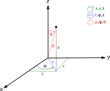
3D Polar 2 3D Cartesian Coordinates Coverter
No Preview Available
Contributor:
happyyasu09
Rating:
Date Added:
12/20/2021
Downloads:
1194
Description:
#P2C-Converter
##Description
Converts Polar Coordinates into Cartesian Coordinates.
##AstroSynthesis Description
This is not an AstroSynthesis plugin but a standalone conversion app written on Python (you need any version of Python as this is super simple app and works on any version starting with 2.7). Read ##Instructions section clearly to run the app!
##Mechanics
-Feeds on data from import.csv;
-Converts degrees into Radians;
-Calculates translation of coordinate systems;
-Produces export.csv file;
##Instructions
Use import.csv that comes with the app to create your own import file, save with radius, polar, alpha columns. Do not use the raw_polar column, as it is there only for specific calculation with image being only visible from a specific view. The excel table provides simple solution to this by switching X and Y coordinates and accounting -12.859 degrees of sheer of the original image.
>Start - Windows Terminal
>
>pip install pandas
>
>cd \path-to-P2C-Converter
>
>P2C-Converter.py
##Story
I created it out of pure interest to see how python is working and I needed an app that converts Polar coordinates of stars based on an image of the galaxy that I created earlier ;)
I have an image of the galaxy drawn on a piece of paper and it was drawn as a whole not as a map. I wasn't able to figure out what X,Y,Z coordinates on that image the stars had so I used Polar Coordinates system to figure out that.
The app takes the FURTHER XYZ 0-Point of an imaginary cube surrounding the image in question.
Reference image: planetcalc.com/users/1/1540029221.png
##Sharing
Feel free to use, share and expand capabilities, provide link to GitHub page if sharing <3 ;)
GitHub Link: github.com/stanleyoutlander/P2C-Converter
###Science Captain Wanda Sol